|
||
|
Issue 62 |
|
2 June 2011 |
|
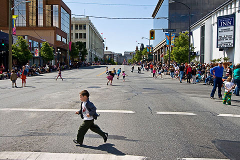 Douglas Street, Victoria, B.C., Canada Victoria Day Parade and Festivities ©2011 R.Bassett AnnouncementsCarfree ConversionsCarbusters recently published the final installment in my series on carfree conversions. I also took this opportunity to polish up Carfree.com's own section on Conversions. All six articles are now on line.The BooksCarfree Cities and Carfree Design Manual are widely available in Europe and North America.CopyleftFor various reasons, I need to continue to maintain the copyrights on my illustrations in Carfree Times. However, effective this issue, the text of Carfree Times is no longer copyrighted. I place the entire text in the public domain, excepting only articles by other authors.
World Carfree NetworkCarfree.com actively supports World Carfree Network (WCN). The main news from the network follows.Towards Carfree Cities X to Be Hosted in GuadalajaraGuadalajara, Mexico, will host TCFC X from 5 to 9 September 2011. This year's theme is "Building Carfree Cities for the People, by the People," with a focus on citizen participation and the sharing of experiences between campaigners from around the world. It promises to be an exciting exchange.World Carfree NewsWorld Carfree News is now available in Czech, English, French, German, Portuguese, Spanish, and Italian. It's a great way to keep abreast of important developments in the carfree cities network.Ecotopia Bike Tour in ItalyThis year's Ecotopia bike tour will travel the length of Italy's boot. Dates are from the beginning of July until mid- to late-August. The subject is local food and sustainable agriculture, and the tour will pass through a number of ecovillages and community projects. More information. |
|
News BitsPeak Car Use?The West's car addiction may be nearing an end. Professors Peter Newman and Jeff Kenworthy recently discovered an unexpected phenomenon they are dubbing "peak car use.""It's a bit like peak oil," said Professor Newman. "We are not noticing the big impacts yet but we have gone over the top. And that peak in car use per capita began in 2004 across the world. ...And US cities are now showing absolute declines in many cases." The car is not disappearing, it's reaching its limits in major cities. "That's the key message," Newman said. "In many ways that is what is happening in these big megacities, they are grinding to a halt in their traffic. ...And most ...are now saying we've got to do something different." "Different" seems to be gaining a foot hold in China and India, where cities have gone on a metro building spree. The metro in Shanghai carries eight million passengers a day and covers 80% of the city. What's happening? According to Newman and Kenworthy, there are six likely causes of peak car use: Hitting the Marchetti wall: This relates to the notion of a "travel time budget" (first identified by Thomas Marchetti) that averages one hour a day. People resist spending more time than this in travel. Newman and Kenworthy have applied this theory to city building, to show that cities hit a wall when they are "one hour wide." An automobile city, based on an average speed of 50 km/hr, can expand to 50km wide. But as cities fill with cars and become increasingly prone to congestion, the auto-centric city hits the wall. The growth of public transport: In recent decades, public transport has not been a major factor in most rich cities. But now the hypothesis is that "by increasing transit per capita, the use of cars per capita is predicted to go down exponentially." This "transit leverage effect" means that even small increases in transit can put a large dent in car use. The reversal of urban sprawl: The increase in the density of cities can be seen as a multiplier on the use of transit and walking/cycling, as well as reducing the length of travel. The return of local shopping in denser, more central parts of cities undermines the growth in car use. The aging of cities: The average age of people in developing cities is rising, and the older people get, the less they drive. The growth of a culture of urbanism: Older folks are moving back into cities from the suburbs. It was not foreseen that the children of the suburbs would drift to cities later in life, but this has been happening for over a decade now. The rise in fuel prices: With the end of cheap oil, fuel prices are reducing car use.
"Peak cars: Is our addiction ending?" Or Cars Forever?"The ultimate symbol of the green industrial promise is the much-hyped electric car, now pushing steadily into the global marketplace, and with models like the Volt, seemingly poised to zoom full-throttle into the future." Sez who? In this case, In These Times."Ideally, a car that runs on a rechargeable battery powered by renewable fuel would curb carbon emissions and rid our streets of dirty exhaust." (And of course that hypothetical source of renewable energy is far from being a reality on the scale necessary to power the world's growing fleet of cars.) The author admits that the energy to run the cars is only part of the problem. The production of cars is another huge unsustainable practice. SOMO, a Netherlands-based consumer-advocacy group, calls corporations to account for environmental and social costs all along the production process, from mining, refining, and right on through the assembly line. A SOMO researcher said, "the supply chain of many of our consumer products causes grave damage to people and the environment around the world. The electric car battery supply chain is no exception." The environmental impact of large-scale mining of lithium (for batteries) disrupts local ecosystems, saps critical water supplies, and encroaches on traditional farming livelihoods in Bolivia, the principal source of lithium. "SOMO's report is not a strike against electric cars, but it is a rare initiative to broaden the conversation in the environmental community to foreground labor and social responsibility issues facing the communities most affected by this budding industry." Well, uh, actually it is a strike. We're committing suicide by pretending that "green" cars will save us.
"Will Electric Car Boom Leave Workers and Environment in the Dust?" More Grim News on Greenhouse Gas EmissionsThe global recession at least reduced the growth of CO2 emissions worldwide, right? Wrong. The Guardian's tag line for their story is "Record rise, despite recession, means 2C target almost out of reach."The relentless increase in greenhouse gas emissions reached record levels in 2010. This pretty much kills any hope of limiting temperature rises to 2°C, which has sometimes been called the threshold for "safe" for climate change (which it really isn't). Fatih Birol, chief economist of the IEA said limiting climate change to this level was likely to be just "a nice Utopia." The most serious global recession in 80 years had no real effect on emissions, contrary to some predictions. The increase was not slight, either, it was more than 5%. Birol said, "I am very worried. This is the worst news on emissions. It is becoming extremely challenging to remain below 2 degrees. The prospect is getting bleaker. That is what the numbers say." I won't bore you with the rest of what was said about this; it's not news and not a surprise. The powers that be steadfastly refuse to take any steps to manage the situation. And the first part of the solution is both simple and attractive to revenue-starved governments: tax carbon at the well head. It's a no-brainer. And it doesn't look like happening any time soon.
"Worst ever carbon emissions leave climate on the brink" And Yet: Sustainable Energy Prospects GoodRenewable sources could provide a majority of the world's energy supplies by 2050 if governments dramatically increase support for wind, solar power, and other renewables. The IPCC reported that the availability of renewable sources was virtually unlimited and could provide up to 77% of the world's energy by mid-century. This won't happen, however, without government policies that encourage the change. Currently, these sources account for only 13% of the global energy supply.The required investments by governments and the private sector is $5.1 trillion through 2020 and $7.2 trillion between 2021 and 2030. (The world currently spends roughly $3 trillion a year on oil alone.) Even so, a "substantial increase of renewables is technically and politically very challenging," said Ottmar Edenhofer, a member of the IPCC. Under the guidance of the IPCC, 120 experts prepared a thousand-page "Special Report on Renewable Energy Sources and Climate Change Mitigation." The report compared more than 160 scenarios on renewable energy. In the second part of the process, government representatives agreed on a "Summary for Policy Makers" that is important to clean energy companies and activists as a tool to press government leaders and lenders to adjust energy policies and redirect investments.
"Renewable Sources Could Provide 77% of World's Energy by 2050, Report Says" Streetcars: Value AddedA 37-mile streetcar system is planned for Washington, DC, which saw the last run on its former streetcar system in January 1962 over a system that once boasted 200 miles of track. The first line is already under construction.The 37-mile system will increase the value of existing properties by $5-7 billion. A further $5-8 billion in new development over 10 years, spurred by the streetcar, is anticipated. The total increase in property value is thus $10-15 billion. The streetcar system itself is expected to cost only $1.5 billion. The study predicted a 20-50% increase in demand for new housing and up to a 15% increase in the value of existing housing. As much as 95% of new office construction is expected to locate near streetcar corridors. The anticipated value increases are supported by experience with projects in Portland, Tampa, Denver, Minneapolis-St. Paul, and Charlotte. The streetcar will put 50% of DC households near rail transit, up from the current 16%. In poorer parts of the city the system will substantially increase access to jobs. If we reach back a century, we find real estate developers who were eager to underwrite the cost of streetcar lines in order to develop property they owned that was otherwise too far from the city center to be attractive to house buyers.
"Wow! Study says DC Streetcar could add $10-15 billion in value" Memorial ServiceHundreds of people gathered at a memorial service held by the South Carolina Department of Public Safety (SCDPS) for the 809 men, women, and children killed on that state's roadways in 2010. The event included music, photographs, a pastoral message, and a video tribute reciting the names of each person who died."Behind each name and each photograph, there is a broken-hearted family or circle of friends that will never be quite the same," SCDPS Director Mark Keel told the audience. Families sent photographs of their loved ones to include in the video. "Although they couldn't come to the service, they wanted to make sure that their family members were not forgotten," Keel said. The service brings together families and friends of the deceased and educates the public in an effort to prevent future tragedies. The services began in 1988 and is the only series of its kind in the USA. I find it rather surprising that this sort of event occurs only in a single state, and one not noted for being in the vanguard of social movements. I am also reminded of the AIDS quilt, begun during the 1980s as a response to the terrible toll this disease exacted during those years in America. It may well have been a defining moment in the politics of the disease when the quilt was unfurled in Washington, DC, and covered most of the Mall. This brought home in a way nothing else did the magnitude of the crisis. Perhaps a similar movement is needed to bring home the human cost of the carnage on our highways. Each year brings the death of about 5000 people who never made it to adulthood because a car cut their lives short.
"SCDPS holds memorial service for traffic fatality victims" Carfree Day in JakartaMost days the main street in downtown Jakarta is noisy, polluted, and congested. Two Sundays a month, however, people-powered vehicles rule the road. Car-Free Sunday is growing in popularity. On any other day, frustrated people stuck in traffic in Jakarta see a chaotic street in a mega-city. On Car-Free Sundays that street becomes a people-friendly zone. Thousands of bike riders take over the road, joined by fearless teenagers on spring-loaded stilts, roller skaters, and groups of people on four wheeled bikes or quadricycles. The only motor vehicles allowed on the road are city buses.The program began in 2007 as monthly environmental program. In the past few years it has grown in popularity and frequency and now occurs twice a month. Car-Free Sunday has become a place to see and to be seen. The idea has spread to other cities in Indonesia. Jakarta officials say the program reduces pollution, but urban planner Suryono Herlambang doubts this claim. He says Car-Free Sunday is an interesting idea, but it does not go far enough to make an impact in a mega-city like Jakarta. Closing one street twice a month, he says, cannot offset the pollution in a city where over a thousand new cars and motorcycles are registered every day. To have any impact, Herlambang says, the city needs to persuade more people to stop driving and use public transport. Jakarta, a city of over nine million people, has a dozen busway corridors with the combined capacity to serve only 500,000 daily passengers. Far more than this is needed. A modern subway system is only on the drawing boards. Compounding the problem are social status issues. Anyone with money won't be seen dead on a bus. As more and more people join the ranks of the middle class, cars are among their first purchases.
"Car-Free Sundays Give Glimpse of Jakarta's Potential"
|
|
Feature ArticlePedestrian Improvements in Dhaka: Attempting the Impossible?By Debra EfroymsonFor those who enjoy quixotic causes, trying to improve the situation for pedestrians in Dhaka presents an enjoyable challenge. The problems with trying to walk in Dhaka are numerous: sidewalks that are broken, covered with construction debris, or blocked with parked cars; the use of public space as a urinal, and the lack of safe street-level crossing facilities, to name a few. (Meanwhile, the government tries to force people to use pedestrian bridges, locally known as footover bridges or, yes, FOBs. For proof of how unpopular they are, just note that the police recently tried to penalize people for not using them with a day in jail!)
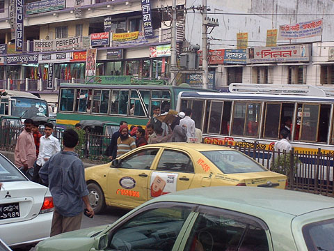 Dhaka Street
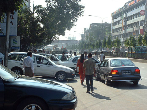 Cars on the Sidewalk, Dhaka
In addition to all that is the fact that the city is dominated by cars. Even though cars make up only 5.2% of primary trips in the city, according to 2010 statistics, and rickshaws account for 38.7%, guess which form of transport the government keeps trying to ban? (The recent news is not good... see the recent article in The New Colonist.) All the noise and smell of the cars, not to mention the danger, makes walking even more unpleasant. A lack of imagination may be one of the reasons why people accept such deplorable conditions in their cities. We are used to streets clogged with cars, to systems that prioritize cars, to space occupied by parked cars, and to utter neglect of and scorn for the pedestrian. For many, it is only a crazy dream to speak of a carfree city or of a city that values those on foot. But what if we used images to show people how things could be? Could that help motivate people to fight for something better? As part of our work on transport, my colleagues at HealthBridge and I have been looking at pedestrian policies and infrastructure in Dhaka, in collaboration with WBB Trust (Work for a Better Bangladesh). I have had the questionable pleasure of reviewing hundreds of pages of policy documents for mention of pedestrians. What I found was that while there is repeated acknowledgement that by far the greatest form of transport by the 12 million residents of Dhaka is walking, "...the needs of pedestrians seemed to be largely ignored despite pedestrians accounting for two-thirds of all reported fatalities" and "despite the high preponderance of walking, pedestrian facilities have traditionally been an afterthought to road improvements." (Sound familiar?) Then come the suggestions: "A major commitment to improve all types of pedestrian facilities is recommended. Not only is this aimed at serving those who have no choice but to walk, it is also to encourage others who have such a choice, to walk more often." And thus the goal of "The creation of a 'Pedestrian First Priority' system to enhance the provisions and protection for pedestrians." But then we leave the language and come to the heart of the matter: the budget. Despite referring to the need for pedestrian priority, the most recent transport plan reserves less than 0.2% of the total budget for pedestrians. Some of the rest of the budget is for mass transit, but a large portion is for elevated expressways and other car-based infrastructure.
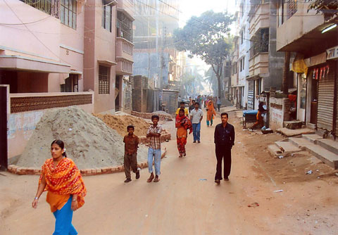 Existing condition
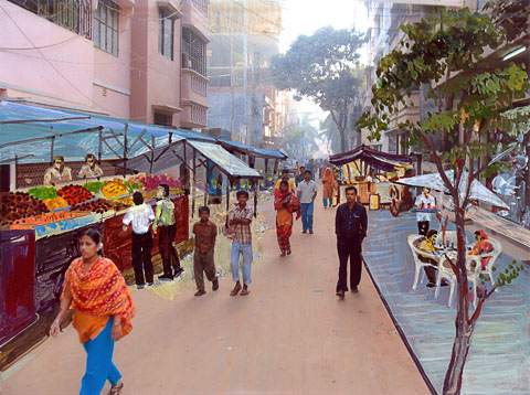 Proposed changes Painting by Pradeep Biswas So much for plans. We then asked an artist to take photos of an unattractive stretch of street and paint in some life: street vendors, people sitting, chatting, enjoying themselves, to show how all that could fit in the space currently being put to essentially no good use. Hence the images shown here.
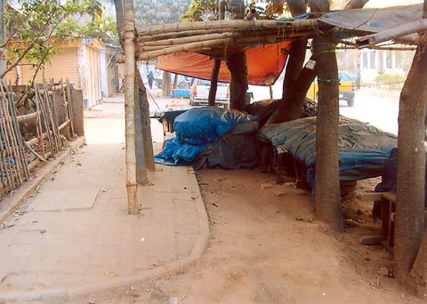 Existing condition
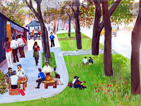 Proposed changes Painting by Pradeep Biswas Of course we can't fix the situation without a good understanding of the ways in which it is broken, and we need good evidence to argue for change. So we are also conducting both observation and perception studies to see where there are sidewalks, whether they are blocked by cars or other objects, what the situation is for crossing the street, and so on. We are stopping people in the street to ask them their opinions about walking in Dhaka. We will then be able to produce a colorful walkability map, and have a good data set to show what problems pedestrians face and what they would most value in terms of improvements. We are often stymied in our work by the apparent lack of solutions to the problems we face. How are we to address fire trucks and freight? How do you convince people to give up their cars? My answer: the creativity and ingenuity is out there to solve far more difficult problems. If we get our priorities right and set our best thinkers to work on such problems, it will not take long at all to come up with a whole set of potential solutions which could be adapted to different places. Instead, we apply our thinkers, engineers, and designers to creating more and more car-based infrastructure. The day that we instead set them to work designing car-free cities, the solutions will seem as obvious as the whole concept should be of returning cities to the people who inhabit them.
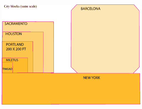
For American planners, Portland, OR is held up as a shining example of urban planning, and credit is given to its compact grid. But is Portland's grid worthy of adulation? Perhaps not, say Fanis Grammenos and Douglas Pollard of Urban Pattern Associates.
In the 4000-year history of the grid, American incarnations are relatively new, appearing first about 300 years ago, frequently as a simple, orthogonal and often square (such as Portland's) "Hippodamian" grid, named after the planner of Miletus around 473 BC (Fig 1). A session in the recent 2009 New Partners for Smart Growth conference focused on "The Beautiful American Grid - the Embodiment of Smart Growth," which lamented the fact that the grid "gets no respect."
This alleged lack of respect seems at odds with most planning literature, which extols its virtues and mirrors prevalent New Urbanist practice. This disparity between theory and practice simultaneously confuses the practitioner and frustrates the theoretician. It deserves detailed attention if only to clarify this schism and enable site plan designers to know when and why they could apply "the Grid." Clarity about its attributes may also open the way for its regeneration. 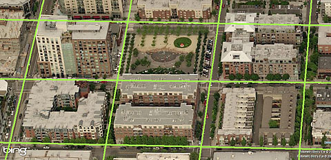 Figure 2. Portland's (Hippodamian) Grid overlaid on a Virtual Earth bird's eye view of Pearl District. The centre lines of streets intersect at 260 foot intervals. For example, in 1992 we read that "Streets ought to be laid out largely in straight segments, as they were until the 1940s. After all, the vast majority of our successful towns and cities, from Cambridge to Portland, were laid out this way." (Duany). The grid gets credit for city success, at least by inference, but is this credit warranted? Portland's network offers an instructive example for discussing grids because of the grid's nature (an unadulterated Hippodamian grid and the densest of all American city grids (Fig 2, MS Earth), its size and the City's planning celebrity status. We read again that "Portland owes much of its success to its tiny blocks that create an incredibly porous network of streets, each of which can be quite small as a result" ( Jeff Speck, 2005). In this praise, it is not simply the grid in general, but the small blocks in particular that impart success. In articles, project brochures and city planning reports "the grid" stands alone; the other contestant, mid-to-late 1900s suburban networks, has been wholly discredited in mainstream planning. One can hardly pay more respect. Affiliation and AffectionPortland's street grid pattern has attracted attention indirectly and directly. Indirectly, because the City of Portland has taken many first-ever, brave and decisive measures to manage growth, and cities and planners hold it up as a model of civic vision. Inevitably, attributes of the city - such as its grid - are seen by affiliation as paradigmatic.Personal testimonies of visiting planners who express adulation for Portland add a second indirect layer of attention. Constantly on the outlook for an ideal urban pattern, planners list Portland as a favorite and some boast "I love that city!" with emotion. Recently, a local movement to rename the city in order to project these strong emotions was set in motion. But strong feelings such as these may be entangled between actual attributes and personal associations, hard to unravel for practical purposes, as other cities also share such emotional investment, at times. Urbanists and romanticists have expressed equally strong sentiments about Paris, London, Barcelona, Curitiba, Amsterdam and Venice. Of the six, only Barcelona adopted the Hippodamian grid in 1859 for its vast expansion, and Venice, without a classic grid, is the preeminent pedestrian haven, yet neither city matches the urbanist's praise for Portland. Whatever the mix of reasons, Portland dominates the American planners' imagination feelings and talk. Disentangling this intangible realm can be an elusive goal; grounds and figures on the other hand may produce tangible results. Grounds and FiguresPragmatic reasons may play a part in this adoration. The extreme simplicity of the plan, for example - a uniform, perfectly orthogonal, expandable checkerboard - could be one. As a drawing, the plan has a feel of flawlessness, the appearance of perfection, particularly in contrast with labyrinthine medieval town plans or recent bewildering suburbs (Figure 3). When this perfection is combined with a pleasant experience on the ground an indissoluble match is made.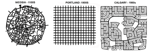 Figure 3 Three networks spanning a millennium: Labyrinthine, confusing Nicosia; perfect, predictable Portland; maze-like, bewildering Calgary (plans to same scale). The degree of connectivity of the street network could count as another practical reason. "Network," by definition, is a set of linked components, whether a spider-net, a fishnet, or the Internet - all networks connect. What distinguishes them is the manner, geometry and frequency of connection: leaf, tree, blood vessels, telephone and web networks are dendrite, hierarchical (fractal) but fishnets are not. Portland's is a dense fishnet with nodes at every 200 feet, which produce 360 intersections per square mile - the highest ratio in America, and 3 to 5 times higher than current developments. For example, older and newer areas in Toronto, typical of most cities, range from 72 to 119 intersections per square mile in suburbs and 163 to 190 in older areas with a grid. As connectivity rose in importance as a planning principle, Portland's grid emerges as a supreme example. Coupled with connectivity, its rectilinear geometry is indisputably more advantageous for navigation on foot, car or bike than any alternatives. Visitors often feel lost and disoriented in medieval towns and in contemporary suburbs and this feeling leads to anxiety and even fear and a sense that all is not well. What explains why the simplest, purest, most interconnected and easily navigated rectilinear grid, in spite of all the praise, has, evidently, not been applied in any contemporary urbanist plan, whether infill or greenfield? What caused the disaffection? The Disaffection: SpeculationOne clue comes out of a believable legend about Portland's grid. Unlike other American cities that were laid out by erudite generals or governors, such as Oglethorpe (Savannah, 1735) or William Penn (Philadelphia, 1701), Portland's plan was apparently conceived by scrupulous speculators who reasoned that more corner lots would yield higher profit on the land investment, hence the maximum number of intersections. Interestingly, the 1812 Commissioners Plan for New York was also denigrated as a "speculator grid." The "speculator" label would usually damage the prospects of any plan; speculation is perceived as shortsighted, greedy, and at times suspect activity - as opposed to "planning" which is a long term, public-good, goal-centered activity.EfficiencyInterestingly, a more contemporary "speculative" calculation may be the equally pragmatic reason for its abandonment. The Portland grid uses 42% of land in right of ways for streets and has the highest length of road infrastructure of any alternatives. Simply put, nearly half of the land is used up in accessing the other half. A recent comparison of an existing 338 hectare subdivision's curvilinear pattern to an overlaid TND plan showed that the land for roads was respectively 88 and 122 hectares or 40% higher for TND with a corresponding increase in infrastructure costs (IBI) (Figure 4). No developer or municipality would savor this arithmetic.In business districts, small blocks may force buildings to gain height and thus increase the per block net density, a financial advantage, but the gross density of such district would be comparatively lower than that of another with larger blocks and similarly tall buildings. On balance, more buildable land means more opportunities to build, tall or otherwise, and therefore more rentable space, revenue and activity. Evidently, Portland's founders either understood little about infrastructure costs or judged them irrelevant; a judgment that no planner, developer or municipality today would take at face value. When economic efficiency matters, Portland's grid fails the grade.  Figure 4. Comparative Building Block sizes of Portland, Suburb and Suburb TND (partial plans). (Note the total eclipse of 4-way intersections in both newer plans). AestheticsReasons that relate to urban design aesthetics can also be seen as contributing to the disaffection with Portland's platting. Starting with Camilo Sitte in 1892, who said categorically: "Artistically speaking, not one of them [grid patterns] is of any interest, for in their veins pulses not a single drop of artistic blood." The string of unfavourable comments continues to 1994 with "Upon reflection, we realized that the developers [who hired us] had a valid concern, one related to the shopping-center developers' understanding that human beings do not like endless vistas." (Duany).This insight into people's behaviour was confirmed by academic research recently (Ewing). Add to this backdrop the common, if superficial, perception of cookie-cutter planning and endless monotony, and distaste for the Portland grid emerges, particularly in eclectic urban designers.EnvironmentSince Ian McHarg's 1969 classic book, Design with Nature, planners have been keenly conscious of the potential negative impact of land development on natural systems. Soon after, pioneering projects, such as Village Homes (1975), responded to this concern. Recently we heard: "The New Urbanism does not do grids that quash nature" (Duany 2001) followed by a movement for Low Imprint New Urbanism in 2007 (LINU). Permeability and rain water management have emerged as key indicators of a plan's fitness. On these measures, the Portland grid occupies the negative end of the spectrum of impermeability with the most road surface. With environmental concerns and regulations rising to the top of the planning agenda, any low performance plan would be disfavoured.Compact, dense development, such as happens in downtowns, lowers the pressure for expansion and its incursion on natural environments. However, though a city's bioregion may be better off, the dense downtowns still exports large amounts of storm water and, with it, pollution. No part of the city need be absolved of the imperative to curb outflow; greening unnecessary asphalt is a viable first step. In that vein, Portland has retrofitted some streets. Safety and mobilityPractical considerations about traffic flow and safety may also undermine its presence in contemporary plans. The term "gridlock" fixed in the planner's vocabulary the sudden realization that the grid and car traffic may, at times, be wholly incompatible and that the conflict increases with the grid's density, as the space for stacking diminishes. The alternative to the grid, 3-way intersections, has been established as the safest and as enabling good flow. (Lovegrove, IBI). When streets in a grid become alternating one-ways, as in most downtowns, they create virtual 3-way intersections throughout an entire district, and achieve both safety and flow. Virtual 3-ways result also from traffic circles, as in Seattle and Vancouver, and from roundabouts, now gaining acceptance in America.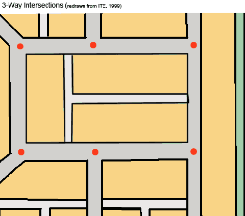 Figure 5. Diagram in ITE's 1999, advisory document on TND street network planning. The ordinary impression on the ground that the Portland grid "works" in contemporary traffic conditions is casually taken as a sign of suitability. This view obscures an entire century of engineered physical, mechanical and management adaptations which are overlaid on the 1866 platting. Remove these (in a thought experiment) and imagine the outcome. Clearly, an ill-suited geometry is made to work with interventions such as dividing lines, medians, traffic signs, traffic lights, directional signs, bollards, street widening, one-ways, traffic circles or roundabouts and many others. Abandoning the GridThe current map of Portland shows the transformations the city's grid has gone through since the 1866 platting, a century before environmental and traffic issues drew the spotlight.In the car-less world of 1891, a variation called 'Ladd's neighborhood' was built, ignoring the surrounding perfect grid and follows a Beaux-Arts, L'Enfant-inspired plan with diagonal streets, (Figure 5) disrupting it.  Figure 6. Three layouts showing the departure from the idea of the "grid" (all plans to same scale) It also introduces a hierarchy of alley, local and collector streets by size and location presaging contemporary urban transportation models. In a sea of formless, perfect uniformity, it brings an organizing module (about 160 acres) that anticipates Perry's Neighbourhood Unit (1923), which also assigns a hierarchy to its streets, and, likewise, protects it from through traffic. Transformations also happened within and beyond the 1866 city outline over time: blocks doubled or tripled in length, some streets became discontinuous and, later, curvilinear streets appeared. More recently, some of the city streets were closed to cars, effectively doubling the block size and introducing a pedestrian space in the middle; an adaptation that produces a high quality public realm which is in short supply in an extensively asphalted grid. All these transformations occurring next to an "ideal" grid leave a trail of desertion which is hard to reconcile with the affection found in literature. ConclusionFor reasons of land efficiency, infrastructure cost, municipal expenses, rainwater management, traffic safety and flow, and the demand for increased pedestrian share of public space, the praised, pure Portland platting will likely not find new followers.
Portland will remain adored and beloved by urbanists, but her Hippodamian grid layout seems destined for the archives, abandoned as a good idea of a bygone era. This transcendence leaves urbanists, who seek to regenerate a contemporary urban pattern that is as pure, complete and systematic, looking for alternatives: ones which excite the same first blush of adoration and delight and lead to a deep abiding love, but also hold up to intense scrutiny of their economic, social and environmental performance.
Douglas Pollard is a Senior Researcher at the Canada Mortgage and Housing Corporation. Originally published at Planetizen. Thanks to them and the authors for allowing this reprint.Additional ResourcesThe Fused Grid: An Urban Pattern for Quality of Life [PDF may load slowly]Developer Questions about the Fused Grid [PDF!] by Fanis Grammenos is available for download from Carfree.com. In the next issue, Fanis Grammenos continues with "Portland's Portal of Opportunity."
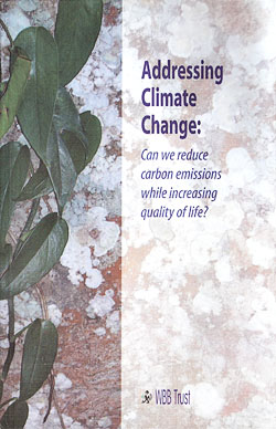
This is another in a series of useful booklets from WBB Trust on contemporary issues affecting health, climate, transport, and urban design. Like its predecessors, this one is to the point and unapologetic for its progressive stance on the issues. The book answers its own question with a resounding Yes! The methods are simple if difficult to implement in today's political climate. We need to regulate the financial sector, reform the tax code, create jobs doing useful work, contract the global economy and focus locally, and reorganize our cities. This can all be done in a way that improves the quality of life for the vast majority of people while admittedly making the super-rich merely very rich. Growth will, of course, have to come to an end. The question then becomes how to distribute what we have so that everyone can live a decent life. This is not a work that will get much attention in Washington these days, but in the places where the Arab Spring is unfolding (which include places well outside Arabia), the new shift to people-centered democracies may give this book a voice and eventually implementation. It will probably come late to the countries that are the worst offenders in climate change: the USA, Canada, and Australia.
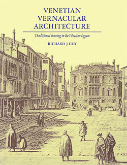
First, I have to complain about this printing. The book was originally issued in 1989, and this printing appears to be a facsimile edition. The text is entirely readable and the line drawings have come through all right, but the photographs are so badly printed as to limit their usefulness. A quality publisher such as Cambridge owes us a better job than this. That said, this book belongs on the shelf of anyone seriously interested in Venice today and how it came to be the way it is. The work is divided into three parts:
I found the discussion of materials and construction methods to be especially interesting. I was a bit surprised to see such a through treatment of the island of Burano, which is a rather minor part of Venice. I have always felt that Burano was an interesting model for relatively inexpensive buildings, individually designed, and sparely ornamented. The resulting urban fabric is, however, highly satisfying. Aside from the printing itself, this is an excellent and useful work.
Video of the Quarter |
|
©2011 DailyCamera.com
Hot New LinksThe links below will open in a new browser window:
"The Bottom Line Speaks" bicycle economics from Bicycle Fixation "The economic case for on-street bike parking" "Fazilka: Come Without Your Car" at Carbusters "Developer bets people will buy tiny 'micro-homes'" "Old Artistery Lot Will Become 29 "Car-Free Micro-Homes"" "Freeway air bad for mouse brain" from Science Blog "Urban nuclei and the geometry of streets: The 'emergent neighborhoods' model" [PDF!] "IPCC: Summary for Policy Makers" [PDF!] 5-8 May 2011
About Carfree TimesNext IssueThe next issue of Carfree Times is scheduled for September 2011.
Subscribe to Carfree TimesCarfree Times is published quarterly at Carfree.com. To receive e-mail notices of new issues, please visit the subscription page or send e-mail with the word "Subscribe" in the subject line. We do not share our mailing list.Write for Carfree TimesInterested in writing for Carfree Times? We welcome articles on a wide variety of subjects and offer an opportunity to publish letters to the editor and guest editorials. Drop us an e-mail.
|
| Editor | J.H. Crawford |
| Send e-mail | |
| URL | http://www.carfree.com/
|
Back to Carfree.com
Carfree Times Home
Back to Carfree Times Issue 61
Forward to Carfree Times Issue 63
E-mail
carfree.com
Illustrations copyright ©2011 J.Crawford
Text original to Carfree Times, except for guest articles, placed in the public domain
